

Analyzing Map 1
Analyzing Maps: Below is the map of Dhaka City important establishments. Now, analyze the map with information in at least 80 words.

Ans: It is apparent that Dhaka city has extended from south to north. The city stands on the bank of the river Buriganga. So the city originates from the south-west part. In the map notice some important establishments which have enriched Dhaka city. We notice International Airport in the north of the city. It is beside the main road and far from the centre of the city. It is at Uttara region. Next the National Zoo is in the north-west of the city. It is in one corner of the city because it needs a big area and it is for entertainment. Dhaka Cantonment stands in the northern part in the centre of the city. In the centre of the city some important places such as Farmgate. Mohakhali. Gulshan and Baridhara are in the north-east part of the city, Dhanmondi is not far off from these places. The most important establishments are in the southern part of the city where all the roads from the north are interconnected. Bangabandhu Sheikh Mujib Medical University and the National Museum are at Shahbagh intersection. Dhaka University and Dhaka Medical College and Hospital are near Shahbagh intersection.
BUET is in between Dhaka University and Dhaka Medical College and Hospital. The higher educational institutions are in the south of the city. Lalbagh Fort is in the south of the city by the river Buriganga. Dhaka College is located at Dhanmondi.
Home Work: Suppose, Hasan’s family has recently moved into a new city. He needs to buy some books. So he needs to go to a library. Now, analyze the map in at least 80 words how Hasan will go to the library in the following map.
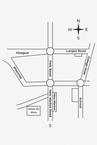
The map shows a simple layout of a town with major roads, landmarks, and three roundabouts connecting important routes. Park Road runs vertically through the center, linking the northern and southern parts of the area. To the north, it meets Lanjeo Road, which runs east–west. A Mosque lies on the western side of this junction. To the east, College Road intersects the map and leads to a School, marked clearly.
Further south, Park Road meets New Market Road, which also runs east–west and connects to New Market on the eastern side. West of this junction lies Khazaniry, a curved connecting road. At the lower-left side, Hasan En Mora is labeled as a landmark off a side road. The map includes a compass showing North, South, East, and West, making navigation easier.
Overall, the map displays a small, organized town structure with clear routes linking key public facilities.
Bengali Meaning:
দেওয়া মানচিত্রটি একটি শহরের সহজ বিন্যাস দেখায় যেখানে প্রধান সড়ক, স্থাপনা এবং তিনটি রাউন্ডঅ্যাবাউট গুরুত্বপূর্ণ পথগুলোকে সংযুক্ত করেছে। পার্ক রোড মানচিত্রের মাঝখান দিয়ে উত্তর–দক্ষিণ দিকে চলে গেছে এবং শহরের উত্তর ও দক্ষিণ অংশকে যুক্ত করেছে। উত্তরে এই রোডটি লানজেও রোডের সঙ্গে মিলিত হয়েছে, যা পূর্ব–পশ্চিম দিকে বিস্তৃত। এই সংযোগস্থলের পশ্চিম পাশে একটি মসজিদ অবস্থিত। পূর্ব দিকে কলেজ রোড মানচিত্রে ছেদ করেছে এবং এই রোডটি একটি স্কুলে পৌঁছেছে।
আরো দক্ষিণে, পার্ক রোড নিউ মার্কেট রোডের সঙ্গে যুক্ত হয়েছে, যা পূর্ব–পশ্চিম দিকে চলে এবং পূর্ব পাশে নিউ মার্কেটের সঙ্গে সংযুক্ত। এই সংযোগস্থলের পশ্চিম দিকে খাজানিরি নামে একটি বাঁকানো সংযোগ সড়ক রয়েছে। মানচিত্রের নিচের-বাম পাশে একটি পাশের রোডের পাশে হাসান এন মোরা নামক একটি স্থানের উল্লেখ আছে। মানচিত্রে উত্তর, দক্ষিণ, পূর্ব ও পশ্চিম—এই চার দিক নির্দেশ করা একটি কম্পাসও রয়েছে, যা দিকনির্দেশনা সহজ করেছে।
সব মিলিয়ে, মানচিত্রটি একটি ছোট ও সুশৃঙ্খল শহরের গঠন তুলে ধরেছে, যেখানে বিভিন্ন গুরুত্বপূর্ণ জনসুবিধা পরিষ্কার সড়কপথের মাধ্যমে সংযুক্ত।
Sample: 2

The maps illustrate simplified layouts of small urban areas using clear black-and-white line drawings. Each map highlights major roads intersecting at roundabouts, with important landmarks placed strategically along those routes. Key locations such as mosques, schools, markets, churches, and hospitals are labeled to show how community facilities are distributed. The maps emphasize orientation by including the four cardinal directions, helping readers understand spatial relationships. Both maps present organized city structures where main roads connect essential services, making navigation easy. Although different in layout and naming, each map serves as an effective visual guide to understanding how important places are linked within a town.
নকশাগুলি ছোট শহরের এলাকার সরলীকৃত বিন্যাস দেখায়, যা পরিষ্কার কালো-সাদা রেখা চিত্র ব্যবহার করে তৈরি। প্রতিটি নকশা প্রধান সড়কগুলিকে প্রদর্শন করে, যা রাউন্ডঅ্যাবাউটের মাধ্যমে সংযুক্ত, এবং গুরুত্বপূর্ণ ল্যান্ডমার্কগুলি সেই রুটগুলির পাশে কৌশলগতভাবে স্থাপন করা হয়েছে। মসজিদ, স্কুল, বাজার, চার্চ এবং হাসপাতাল-এর মতো প্রধান স্থানগুলি লেবেল করা হয়েছে যাতে বোঝা যায় কমিউনিটি সুবিধাগুলি কিভাবে বিতরণ করা হয়েছে। নকশাগুলিতে দিকনির্দেশ বোঝানোর জন্য চারটি প্রধান দিক অন্তর্ভুক্ত করা হয়েছে, যা পাঠককে স্থানীয় সম্পর্ক বুঝতে সাহায্য করে। উভয় নকশা একটি সুসংগঠিত শহুরে কাঠামো উপস্থাপন করে, যেখানে প্রধান সড়কগুলি গুরুত্বপূর্ণ সেবা কেন্দ্রগুলির সাথে সংযুক্ত, যা নেভিগেশন সহজ করে। যদিও বিন্যাস ও নামকরণ ভিন্ন, প্রতিটি নকশা শহরের গুরুত্বপূর্ণ স্থানগুলি কিভাবে সংযুক্ত তা বোঝার জন্য কার্যকর ভিজ্যুয়াল গাইড হিসেবে কাজ করে।